Monday, October 18, 2010
Friday, September 24, 2010
Family biking from Alaska to tip of South America
http://familyonbikes.org/
WOW!! What an adventurous family...biking and home teaching the whole way!!
Teachers, help your students learn geography by following the travels and adventures on their travel blog!
WOW!! What an adventurous family...biking and home teaching the whole way!!
Teachers, help your students learn geography by following the travels and adventures on their travel blog!
Monday, September 20, 2010
This is who we are..Living in Utah video
Pause the music widget before playing this great video (scroll down...on right side)
Wednesday, September 15, 2010
Friday, September 10, 2010
SkyWatch Friday


For more interesting skyviews:
A thunderstorm rumbled through our area recently...as the storm began to clear, the afternoon sunlight reflected off the heavy storm clouds creating a very beautiful "heavenly" view.
Cheers to SkyWatch Friday viewers!


Friday, August 27, 2010
Skywatch Friday...Moon & Jupiter

Skywatch Friday
See other amazing sky images:
http://skyley.blogspot.com/
Light from the large waning moon was peaking through the clouds this morning......forming a "moondog"
(rainbow) of sorts. Pretty site with brightly shining Jupiter nearby.
Tuesday, August 24, 2010
The science of a Journey Through the Center of the Earth
I've seen a lot of explanations about digging a hole through the earth.....but this on from Neil deGrasse Tyson / NOVA scienceNOW NOVA Short Journey Through the Center of the Earth is the best!!
(mute sound from playlist popout below before viewing video)
For lesson plans related to this subject, view my 2/21/09 blog post:
How to dig a hole to the center of the earth
(mute sound from playlist popout below before viewing video)
For lesson plans related to this subject, view my 2/21/09 blog post:
How to dig a hole to the center of the earth
Wednesday, June 16, 2010
BLOG UPDATE
I've been away from my blog for awhile. My Mother had a massive stroke and my Father fell (crushed a vertebrae in his back & contacted MERSA in the hospital). My life has become a blurr of paperwork, hospitals and long term care facilities for both ......
Please feel free to search my blog for geography teaching tools and resources in the mean time...
Thanks for your patience and come back to visit soon!
Please feel free to search my blog for geography teaching tools and resources in the mean time...
Thanks for your patience and come back to visit soon!
Wednesday, May 26, 2010
Utah State Geographic Bee winner will compete in Finals today at NGS
Anthony Cheng survived the preliminaries of the National Finals Geographic Bee Competition in WashingtonDC. He competes today as one of the top ten finalists in the Finals competion today. Good Luck Anthony!!!!
Friday, May 21, 2010
NPR: Along the Grank Trunk Road series....
I've been away from my blog for awhile. My Mother had a massive stroke and my Father fell (crushed a vertebrae in his back & contacted MERSA in the hospital). My life has become a blurr of paperwork, hospitals and long term care facilities for both ......
But for now.... NPR radio has sponsored a series all week on their Morning Edition show: Alog The Grand Trunk Road. NPR reporters have been travelling and reporting their experiences from the old Asian "Grand Trunk Road". If you missed this series, it is all available on their website including audio files, slide shows, and maps of the grand journey....FABULOUS
http://www.npr.org/templates/story/story.php?storyId=126395475
Thursday, May 20, 2010
Friday, April 23, 2010
Earth Day links
A terrific website for kids with lots of online geography (Earth Day) activities:
http://funschool.kaboose.com/globe-rider/earth-day/
http://funschool.kaboose.com/globe-rider/earth-day/
National Park Week..free admission
All national parks free for a week - The Denver Post: "All national parks free for a week
By The Denver Post
Posted: 04/16/2010 05:18:18 PM MDT
Updated: 04/16/2010 05:21:15 PM MDT
Admission to all 392 national parks — including four in Colorado — is free April 17-25 during National Park Week.
Colorado's parks are the Great Sand Dunes National Park in the San Luis Valley, the Black Canyon of the Gunnison National Park in western Colorado, Rocky Mountain National Park along the Continental Divide, and southwest Colorado's Mesa Verde National Park.
The normal cost is $20 per vehicle in Rocky Mountain National Park, $15 per vehicle in the Black Canyon of the Gunnison park and $10 per vehicle in Mesa Verde. The regular cost in Great Sand Dunes is $3 per person.
Saturday, April 24, is National Junior Ranger Day, when kids can take part in special activities and earn an official Junior Ranger patch.
Most parks also are planning special volunteer events, giveaways and discounts during the week to celebrate the 40th anniversary of Earth Day, April 22.
Mesa Verde, for example, is offering 40 percent off T-shirts made from recycled material, as well as a free pack of Colorado wild flower seeds to each visitor all week.
For more information visit www.nationalparkweek.org or www.nps.gov."
Thursday, April 22, 2010
Earth Day links
From the Utah Geographic Alliance website:
40th Anniversary of Earth Day (April 22) Below are a few websites with resources that may be useful as you engage your students in the celebration of Earth Day.
40th Anniversary of Earth Day (April 22) Below are a few websites with resources that may be useful as you engage your students in the celebration of Earth Day.
http://earthday.net/greenschools http://earthday.wilderness.org/teachers/ http://earth911.com/for-students/ http://www.planetpals.com/earthday.html http://www.edhelper.com/EarthDay.htm http://www.epa.gov/kids/ http://news.nationalgeographic.com/news/environment.html http://www.earthday.org/climaterally http://www.nationalgeographic.com/xpeditions/lessons/18/g35/earthday.html http://www.ngslis.org/earth_current/20080229.html
Wednesday, April 21, 2010
Sun Size and Altitude - Earth Science Picture of the Day
Great article and example of why we build telescopes on high mt. tops.
From a Great Website:Earth Science Picture of the Day!
Sun Size and Altitude - Earth Science Picture of the Day: "Sun Size and Altitude
April 21, 2010
Photographer: Rob Ratkowski
Summary Author: Rob Ratkowski
Astronomers are frequently asked why we have our observatories on high mountain tops. A big part of looking into deep space has to do with atmospheric transparency and freedom of particulates along with heat that causes blurring. A simple but effective understanding of this 'seeing' is to put a finger at arm’s length in front of the Sun and observe the aureole that’s produced. Held at arm’s length, a finger tip subtends about one half of a degree of sky – nearly the same amount of space that both the Sun and Moon take up. At sea level, observing is often compromised by the build up of heat, dust, moisture, haze, pollution, and aerosols that include ash and even salt. Higher up, there’s less of this to deal with since there’s less atmosphere to peer through. These three photos were taken on the Hawaiian island of Maui at (left to right) Baldwin Beach, Kula and Haleakala Observatory, respectively. The disk of the Sun is completely hidden by my index fingertip at 10,000 ft (about 3,050 m). Note, I can positively verify that my finger didn’t increase in size as a result of the thinner air.
Coordinates:
Baldwin Beach: 20.913502,-156.394544
Kula: 20.79222, -156.32694
Haleakala Observatory: 20.70825, -156.256678
Tuesday, April 20, 2010
Geography of U.S.National Parks
CHECK THIS SITE OUT!
RACE TO THE MOMENT is a reality series were two families use their physical and geography skills to negotiate their way through Joshua Tree National Park. Watch the race, or design and map your own race in other U.S. National Parks!
1=25070#/show">http://racetothemoment.msn.com/?section=challenge&dataId=201&source=msn>1=25070#/show
Monday, April 19, 2010
Icelandic volcano eruption lesson plan
See One of my favorite blogs and teacher geography resource blogs:
http://www.geogalot.com/
This blog's author, Richard Allaway, produced a webpage of resource to help teach about the Eyjafjallajoekull Eruption and Ash Cloud - you can read all about the resources here:
http://www.geogalot.com/experiences/2010/4/19/eyjafjallajoekull-eruption-ash-cloud-lesson-resources.html
Check out his blog and sign up for his newsletter...I've found tons of fabulous lesson plans and teacher resources from his blog!!!
Thursday, April 1, 2010
SkyWatch Friday
 See other interesting sky views:
http://skyley.blogspot.com/
 PAIRS OF PLUMP PIGEONS (MORNING DOVES) PERCHED IN ORNAMENTAL PEAR TREES...
 PAIRS OF PLUMP PIGEONS (MORNING DOVES) PERCHED IN ORNAMENTAL PEAR TREES...
Friday, March 12, 2010
GLOBE AT NIGHT PROGRAM

How many stars can you count in Orion from where you live? Help shed light on light pollution! Take a few minutes to monitor your local night sky brightness and submit your measurement online. With half the world’s population now living in cities, light pollution is a huge problem; yet you can easily be part of a local solution. The "GLOBE at Night" campaign runs from March 3 to March 16, 2010.
http://www.globeatnight.org/
http://www.globeatnight.org/
This great little website has family and teacher activity packets available for download related to this event, as well as podcasts, posters, postcards and all kinds of graphs charts and maps dealing with light pollution.
Count the stars of Orion tonight and register your star count with this program....FUN
Thursday, March 11, 2010
SkyWatch Friday: Moon caught in a tree

See more intriguing sky sights at:
http://skyley.blogspot.com/
 Lucky me.. again I saw the moon "caught" in a tree!!
It can't get out without a doubt.
But it's okay for a post today....
a special picture for (SW) Friday!!
Cheers! & Happy SWFriday!!!

Thursday, March 4, 2010
SkyWatch Friday: Tree that held up the Moon
 To see other groovey sky views:
http://skyley.blogspot.com/
 This not a real great photo, but I saw this big full, orange morning moon, and ran to get my camera.
I took several photos and this one was the 'best".
I was looking so much at the moon that I didn't realize how much of the tree was in the way....its funny the tree looks like its "holding" the moon up in its branches--a lunar ornament of sorts.
Cheers!!!
NASA - Google Earth Application Maps Carbon's Course
Check out this new Google Earth application layer from NASA...INCREDIBLE!!
NASA - Google Earth Application Maps Carbon's Course: "Google Earth Application Maps Carbon's Course"
NASA - Google Earth Application Maps Carbon's Course: "Google Earth Application Maps Carbon's Course"
National Clearinghouse for United States-Japan Studies
Need educational materials about Japan? See the SPICE program link to National Clearinghouse for U.S. - Japan Studies
http://spice.stanford.edu/docs/clearinghouse/
INTERNET TEACHER GUIDES:
http://spice.stanford.edu/docs/147

http://spice.stanford.edu/docs/clearinghouse/
INTERNET TEACHER GUIDES:
http://spice.stanford.edu/docs/147

Wednesday, March 3, 2010
How the Chiliean Earthquake Moved the Earth
A podcast from NPR radio, Morning Edition, 3/3/10
with more details about how the earth changed from the gigantic Chiliean earthquake:
with more details about how the earth changed from the gigantic Chiliean earthquake:
Tuesday, March 2, 2010
Chili Quake effected the whole earth
(turn down sound or pause music widget in dashboard before viewing video)
Visit msnbc.com for breaking news, world news, and news about the economy
Saturday, February 27, 2010

Thursday, February 25, 2010
SkyWatch Friday
 To see other interesting sky views:
http://skyley.blogspot.com/

I LOOKED TO THE SKY AND WHAT DID I SEE?
A WEE BIT OF SPRING LOOKING BACK AT ME!!
CHEERS!
HAPPY SKYWATCH FRIDAY
Wednesday, February 24, 2010
Video for elementary teachers
This is TOOO FUNNY....and SPOT ON!!! Enjoy!!
(Turn off background music in dashboard widget before viewing
so you can truly enjoy this video clip!)
This is from the show The Seven Habits of Highly Ineffective Educators. Wavelength trains teachers. Learn more at www.wavelengthinc.com
(Turn off background music in dashboard widget before viewing
so you can truly enjoy this video clip!)
This is from the show The Seven Habits of Highly Ineffective Educators. Wavelength trains teachers. Learn more at www.wavelengthinc.com
Tuesday, February 23, 2010
Animaniacs: Nations of the World song
Animaniac's: Nations of the world song
(turn down the music from the dashboard music widget
so you can hear this....)
(turn down the music from the dashboard music widget
so you can hear this....)
geography songs
If you ever needed or wanted a list of geography songs....try this HUGE geography song blog by
Eric Riback:
http://ericssonglists.blogspot.com/
also see his great blog: MAPVILLE !!!!!
http://mapville.blogspot.com/
Eric Riback:
http://ericssonglists.blogspot.com/
also see his great blog: MAPVILLE !!!!!
http://mapville.blogspot.com/
Using children's literature to teach geography
- I found an EXCCELLENT geography lesson plan (using childrens' literature) from Geographic Alliance of Iowa:
http://www.uni.edu/gai/Lesson_plans/Teaching_Geography_using_literature.html
- Minn of the Mississippi
- Paddle-to-the-Sea
- Seabird
"These books are by Holling Clancy Holling....and are very geography content laden.... it is appropriate to be used from grade 4-9. "![]()
Book available at Amazon.com:
http://www.amazon.com/exec/obidos/ASIN/0395273994/litplanscom-20
James Michener on Geography
James Michener on Geography
The Queenly Science
(A geography quote from About.com)
"The more I work in the social-studies field the more convinced I become that Geography is the foundation of all. When I call it the queenly science, I do not visualize a bright-eyed young woman recently a princess but rather an elderly, somewhat beat-up dowager, knowing in the way of power.
When I begin work on a new area – something I have been called upon to do rather frequently in my adult life – I invariably start with the best geography I can find. This take precedence over everything else, even history, because I need to ground myself in the fundamentals which have governed and in a sense limited human development. … Most geography books, like most geography courses, are drab affairs and a waste of time. I have dissipated many hours looking at geographies that were not worth the reading, but when you come upon something like Preston James' speculative works on South America the philosophical returns are apt to be high. However, even the poorest regional geography is better than none at all; it at least delimits the field, fixes certain relationships, and drives the reader to a contemplation of his own.
With growing emphasis on ecology and related problems of the environment, geography will undoubtedly grow in importance and relevance. I wish that the teaching of it were going to improve commensurately; most of the geography courses I have known were rather poorly taught and repelled the general student like me.
I could make the same wish about geographical writing. It ought to be much better than it is, with more emphasis upon generalization and philosophical meaning. Television has done much to awaken the general viewer to geographical matters – but this is merely a pleasant tourism, sight-seeing. What is required is the perceptive analysis of the land and man's relationship to it. If one has this solid footing, then the television travelogue can be of enormous additional value. Without it, the television program is harmless entertainment and provides little evident for reaching conclusion on major problems.
If I were a young man with any talent for expressing myself, and if I wanted to make myself indispensable to my society, I would devote eight to ten years to the real mastery of one of the earth's major regions. I would learn languages, the religions, the customs, the value systems, the history, the nationalisms, and above all the geography, and when that was completed I would be in position to write about that region, and I would be invaluable to my nation, for I would be the bridge of understanding to the alien culture. We have seen how crucial such bridges can be.
Believe me, if I were well schooled in one of these vital areas and if I had even a modest gift for writing I would have an insurance policy for the rest of my life, because we need perceptive books about these cultures."
Extract from "The Mature Social Studies Teacher," Social Education, November, 1970. pp. 760-767
EarthSky.org -- Geography podcasts
http://earthsky.org
Listen to FREE, ONLINE ,daily, EarthSky.org podcasts...fascinating science, space and geography subjects! You may download the daily/weekly podcasts or embed their podcasts into a blog, etc.
I used them every morning with my 6th grades classes as a "listening" (comprehension) class starter. The kids listened to the podcast, jotted down a few notes about what they heard and we discussed the topic for a few minutes. The kids turned in their "Earth&Sky" notes every Friday...I was able to give them a comprehension and class participation grade from their work.
(turn off the music gadget in the sidebar if you wish to listen to the podcasts now...)
Thursday, February 18, 2010
SkyWatch Friday
 See other exciting skyviews:
http://skyley.blogspot.com
It was a dark and dreary winter morning...menacing clouds piled up against the Wasatch Mountains in Utah County. For a brief moment the sun attempted to scatter a few rays of light onto those of us waiting so desperately for spring to arrive. This picture made me a feel a little less snowbound and a lot more springy... Cheers and Happy Sky Watching!!!

Friday, February 12, 2010
Storm could mean snow on ground in all 50 states - USATODAY.com
Several articles and news items have shown up today talking about all 50 states having snow on the ground.
Here's the article from USATODAY.com:
Storm could mean snow on ground in all 50 states - USATODAY.com
This same website/article above has a great interactive map showing snow in all the States:
http://www.usatoday.com/weather/news/2010-02-11-nationwide-snow_N.htm?csp=hf
Here's the article from USATODAY.com:
Storm could mean snow on ground in all 50 states - USATODAY.com
This same website/article above has a great interactive map showing snow in all the States:
http://www.usatoday.com/weather/news/2010-02-11-nationwide-snow_N.htm?csp=hf
2010 Olympic Medal Tracker
Lots of opportunities to teach geography during the Winter Olympics!!
Start by downloading this free widget from the 2010 Vancouver Winter Olympics site:
http://www.nbcolympics.com/widgets/index.html
Give each student a large black-line world map to use during the Olympics...students can begin by identifying on the world map the countries participating in the Winter Olympics..then marking tally marks on countries winning medals.
OR CHECK OUT THIS SITE: http://www.vancouver2010.com/olympic-medals/geo-view/
The official Vancouver Winter Olympics has a interactive online world map showing all of the participating countries that will show an ongoing tally of medals for each country....THANK YOU VANCOUVER WINTER OLYMPICS FOR ADDING A GEOGRAPHY COMPONENT TO YOUR OLYMPICS!!!
Another idea that I have used with my students in the past:
Record,download,watch online from the websites, the opening ceremony of the Olympics...especially where the teams enter the stadium with their country's flags. Show the recording to students...(you can leave the sound off)..and as each country's flag pass...students identify the flag and identify the country on a black-line map of the world. (Current World Almanacs will help with flag identification).
Thursday, February 11, 2010
SkyWatch Friday

To see other interesting sky views:
http://skyley.blogspot.com

A cold Utah County morning....after a big snow storm. The light on these trees made the scene very "painted' or unreal looking...brrrrr.
Bring on Spring!!!
Monday, February 8, 2010
GEOGRAPHY QUOTE

"In his last years my father would sit on the porch of his Long Island nursing home looking out on the sea, and between long silences he would speak. “You know, sometimes I see a little dot way out there, and then it gets bigger and finally turns into a ship.” I explained that the earth was a sphere and so forth. In his 80 years he had never had time to sit and watch the sea. He had employed hundreds of people and made tens of thousands of coats and shipped them to towns and cities all over the States, and now at the end he looked out over the sea and said with happy surprise, “Oh. So it’s round!”
Arthur Miller, Timebends
Friday, February 5, 2010
SkyWatch Friday
 To see other interesting sky views:
http://skyley.blogspot.com/
I found a cool website to help explain the following moon pictures:
http://home.hiwaay.net/~krcool/Astro/moon/moonring/ey.blogspot.com/
 *Moon halo?
*Moon dog?
*paraselene?*ring around the Moon?
*Moon corona?
What ever you wish to call this pretty moon site..took me quite awhile and lots of shots to capture these three pictures. Either the clouds covered the moon or the "rainbow colors" were not visible enough. I was excited to get these three!

HAPPY SKYWATCHING!

Tuesday, February 2, 2010
NOVA: Ghosts of Machu Picchu

PBS/NOVA is premiering new program today : The Ghosts of Machu Picchu.
http://www.pbs.org/wgbh/nova/machupicchu/ The companion website is loaded with all kinds of teacher materials and resources. The entire program can be viewed online starting 2/3/10.
http://www.pbs.org/wgbh/nova/teachers/lessonideas/3704_machupicchu.html
From the "Teacher Resource" link above see media-rich lesson plans using this program.
http://www.pbs.org/wgbh/nova/teachers/lessonideas/3704_machupicchu.html
From the "Teacher Resource" link above see media-rich lesson plans using this program.
Monday, February 1, 2010
Cross-Quarter Days

REPOSTING:
Happy Ground Hog Day ..with an
"astronomy-geography" connection!!!
Did you know that Ground Hog Day
is a cross-quarter day?

For more information about astronomy and Cross-Quarter Days, see:
A cross-quarter day is a day falling approximately halfway between a solstice and an equinox. These days originated as pagan holidays in Sweden, Norway, Finland, United Kingdom and Ireland, and survive in modern times as neopagan holidays.
The Cross-Quarter Days:
1 November
1 November
2 February
1 May )
1 August
1 May )
1 August
From Wikipedia:http://en.wikipedia.org/wiki/Cross-quarter_day
"There are Christian and secular holidays that correspond roughly with each of these four, and some argue that historically they originated as adaptations of the pagan holidays, although the matter is not agreed upon. The corresponding holidays are:
St.Brigids Day (1 February), Groundhog Day (2 February), and Candlemas (2 or 15 February)
Walpurgis Night (30 Apr) and May Day (1 May)
Lammas (1 August)
Halloween (31 October), All Saints (1 November), and All Souls' Day (2 November)"
St.Brigids Day (1 February), Groundhog Day (2 February), and Candlemas (2 or 15 February)
Walpurgis Night (30 Apr) and May Day (1 May)
Lammas (1 August)
Halloween (31 October), All Saints (1 November), and All Souls' Day (2 November)"
For more Cross-Quarter Day information see:
Cross-Quarter Day lesson plan:
Thursday, January 28, 2010
SkyWatch Friday
 See other interesting sky sites
http://skyley.blogspot.com
 I just stepped out my back door and
saw this pretty view! The snowy peak of
Mt. Timpanogos is poking up from the
hazy valley smog, and the sunset light is tinting
the mountain a pretty pink..paired with a white
moon...blue, pink, white,....nice site!!!
(Mt. Timpanogos is part of the Wasatch Front Mountains in Utah County, Utah, USA)
Wednesday, January 27, 2010
Another Great Geography Quote
Another great geography quote from the book:
"Big Tiger and Christian" by Fritz Muhlenweg.
Big Tiger had never had a map in his hand before, but he pretended to know all about maps and remarked airily: “I can’t read the names on this one because they’re in English.” Christian realized he would have to show his friend how to read a map. “The top is north,” he said. “The little circles are towns and villages. Blue means rivers and lakes, the thin lines are roads and the thick ones railways.” “There’s nothing at all here,” said Big Tiger pointing to one of the many white patches. “That means it’s just desert,” Christian explained. “You have to go into the desert to know what it looks like.”….. “That’s a fine map,” said Big Tiger. “It’s useful to be able to look up beforehand the places we reach later.”….. “Are there bandits about here?” asked Christian. “Perhaps it’s written on the map,” Big Tiger ventured. “Look and see.”….. "
Article about this book:
http://www.allthingsransome.net/rrreviews/bigtigerandchristian.html
Holocaust Remembrance Day
Did you see this?
News about International Holocaust Remembrance Day
International Holocaust Remembrance Day (VIDEO) Marked By Netanyahu
Netanyahu marks International Holocaust Remembrance Day - The Jewish community must continue to fight anti-Semitism, Israeli Prime Minister Binyamin Netanyahu said Monday. Speaking in Jerusalem at Yad Vashem, Israel's official memorial to the Jewish ... - Post Chronicle
http://www.bing.com/newsq=International+Holocaust+Remembrance+Day&FORM=TASKCB
Other online resources:
*For an online virtual tour of Auschwitz-Birkenau:
http://www.remember.org/auschwitz/aus.php
*UNESCO.org World Heritage Site:
http://whc.unesco.org/en/list/31
*Jewish Virtual library: Auschwitz-Birkenau:
http://www.jewishvirtuallibrary.org/jsource/Holocaust/auschbirk.html
*The interactive Web site, located at www.footnote.com/holocaust
, offers more than 1 million Holocaust-related documents. It is a collaboration between the National Archives and Records Administration, the U.S. Holocaust Memorial Museum and Footnote.com, based in Lindon, UTAH.
Weekly EarthSky.org podcast player
http://earthsky.org
Listen to FREE, ONLINE ,daily, EarthSky.org podcasts...fascinating science, space and geography subjects! You may download the daily/weekly podcasts or embed their podcasts into a blog, etc.
I used them every morning with my 6th grades classes as a "listening" (comprehension) class starter. The kids listened to the podcast, jotted down a few notes about what they heard and we discussed the topic for a few minutes. The kids turned in their "Earth&Sky" notes every Friday...I was able to give them a comprehension, geography, grammar, and class participation grades from their work.
(turn off the music gadget in the sidebar if you wish to listen to the podcasts now...)
GEOGRAPHY QUOTE
One of my favorite quotes from "Heart of Darkness", by Joseph Conrad
"Now when I was a little chap, I had a passion for maps. I would look for hours at South America, or Africa, or Australia, and lose myself in all the glories of exploration. At that time there were many blank spaces on the earth, and when I saw one that looked particularly inviting on a map, (but they all looked like that) I would put my finger on it and say, “When I grow up I will go there.”
"Now when I was a little chap, I had a passion for maps. I would look for hours at South America, or Africa, or Australia, and lose myself in all the glories of exploration. At that time there were many blank spaces on the earth, and when I saw one that looked particularly inviting on a map, (but they all looked like that) I would put my finger on it and say, “When I grow up I will go there.”
CHILDREN'S GEOGRAPHY LITERATURE
CHILDREN'S GEOGRAPHY LITERATURE:
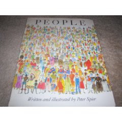 "PEOPLE" by Peter Spier
("People" explores diversity of the world's population. Looks at various cultures, homes, food, games, clothing, faces and religions.)
I found many lesson plans for this book, mostly for K-3 usage like this link:
http://www.learnnc.org/lp/pages/3254
I found this lesson plan for 4+grades usuage:
http://alex.state.al.us/lesson_view.php?id=3042
Amazon.com link:
http://www.amazon.com/People-Peter-Spier/dp/038524469X#noop
I am going to start posting recommended geography-based literature WITH LESSON PLANS...SO MANY GREAT PICTURE/NOVEL BOOKS to help teach geography using literature!!!
Starting with this title: "By the Great Horn Spoon!", by Sid Fleischman"
Related lesson plan found at this link:
http://education.boisestate.edu/compass/Facultyroom/LessonvaultAIG/GeoLit.htm
Book available through Amazon.com:
http://www.amazon.com/Great-Horn-Spoon-Sid-Fleischman/dp/0316286125
Sunday, January 24, 2010
Helping your child learn Geography
The following information comes from an older, but very useful booklet, produced by the US Geological Survey and US dept of Education: "Helping Your Child Learn Geography". It is in public domain and so duplication rights are allowed. I used this booklet for years...gave many copies to parents at back to school night or during parent/teacher conferences... to encourage the teaching of geography at home.
The whole booklet 9for download) can be found at the following website:
http://readyweb.crc.uiuc.edu/virtual-library/1990/geo/helpgeo.html
This booklet has a useful list of geography based literature picture/reading/story books and other resources (some outdated)...in the back of the book ..
Helping Your Child Learn Geography
--------------------------------------------------------------------------------
Table of Contents
--------------------------------------------------------------------------------
Foreword
Introduction
Chapter 1: Position on the Earth's Surface
Chapter 2: Place: Physical and Human Characteristics
Chapter 3: Relationships within Places: Humans and Environments
Chapter 4: Movement: People Interacting on the Earth
Chapter 5: Regions: How They Form and Change
Conclusion
References
Glossary
Free or Inexpensive Materials
Books
Acknowledgments
--------------------------------------------------------------------------------
This booklet is in the public domain. Authorization to reproduce it in whole or in part for educational purposes is granted.
Return to the Virtual Library page.
Return to the ReadyWeb Home Page.
Stage an International Fair
This activity is from an older National Geographic Society's Geography Awareness Week packet of materials...This is an activity that could be used any time during the year to study geography/countries!! Permission was granted for teachers to copy and use the materials in the GAW packet:
"GEOGRAPHY: PASSPORT TO THE WORLD
INTERNATIONAL FAIR
INTRODUCTION:
Here's a chance to highlight geography in your class, your school, and your community-and have a great time while you're at it. Convert your classroom or your entire school into a fanfare of "countries," with students representing peoples and their cultures around the world. Then, on the last day of Geography Awareness Week, hold an international fair and include parents, other members of the community, and the media. Get a lively press release out ahead of time. The message for geography as a passport to the world will fly far and wide.
MATERIALS:
To make passport stamps: potatoes, paring knives, stamp pads or paint-or other materials for other kinds of stamps.
PROCEDURE:
Divide the class into small groups. Have each group choose a country. (If you recruit other classes to participate in this activity, each classroom can represent one country.) Ask the students to research the culture of their country during the course of the week, and prepare to show aspects of the culture on the day of the fair. Some ideas for country booths:
• Wear national dress
• Play indigenous music
• Display local textiles
• Stage language demonstrations and lessons
• Perform folk dances
• Show official currency
• Set out guidebooks, travel brochures, maga-zines, and newspapers
• Demonstrate games
• Display pictures of political figures and national heroes
• Serve local food
• Invite someone who has visited that country or lived there to show slides and give a talk
• Paint the country flag on tagboard or on a bedsheet
Have each group of students design an official passport stamp for their
country to be used in other students' passports. If possible, have the class examine actual passport stamps, or use the ones on this page as models. Possible means of making stamps: Carve the stamp from a large potato sliced in half; assemble a stamp from rubber letters and numbers; decorate small white adhesive labels and cut them into official shapes.
Appoint immigration officers to stamp passports as tourists enter the countries, and designate tourist information officers to answer questions
about the country. On the day of the fair or the last day of Geography
Awareness Week--divide each country group so that the students can take turns running their country and visiting other countries. The students should use the passports made in the activity on page 3 (see passport below) for stamped entry into other countries.Invite students from other rooms to visit¬carrying their own passports, of course. Though the fair takes place on the last day of the week, the activity will work best if students select their countries on the first day and devote time daily to preparation. You may want to start preparing for this activity before the week begins." (double click on each of the two images below to enlarge & print.)
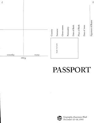
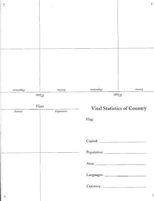
"Passport Assembly:
Photocopy the two 8 1/2 x 11" passport templates at right (above) and distribute one set to each student. Have the students assemble their passports in the following way:
A. Cut the two 8 1/2" x 11" pages apart along the dotted line if they were photocopied together.
B. Place each of the two pages, blank side down, on a flat surface in front of you so that you can read the words "PASSPORT" and "Vital Statistics" correctly.
c. Fold each page in half, across the center, with type facing outward. The words "PASSPORT" and "Vital Statistics" should now read across near the top of each fold.
D. Fold each paper again, like a book, so that the words "PASSPORT" and "Vital Statistics" are on the covers.
E. Insert the section with "Vital Statistics" into the center of the "PASSPORT" section and staple together along the edge of the spine-so that the staple ends are on the back side of the booklet. "
Thursday, January 21, 2010
SkyWatch Friday
 To see other interesting sky views:
 These photos are not necessarily sky views, but definitely sky-ward looking!
These rock formations are found in Weber Canyon (Wasatch "back" of the Wasatch Front Range Mountains in Utah) and are locally called "The Devil's Slide". I found a great Utah Geological Survey website that describes how this formation came to be as seen today.
http://geology.utah.gov/surveynotes/geosights/devilsslide.htm


Friday, January 15, 2010
SkyWatch Friday
 See other interesting sky views:
http://skyley.blogspot.com
A flock/covey of morning doves have taken up residency in
my backyard; mostly harvesting the morsels of food from three
flowering pear and two crabapple trees. This is not exactly a
a sky view, but it has been so smoggy and foggy here lately that
our Utah mountains and skies are hidden...catching a picture or two of the
birdies is just about the only thing not hidden in the fog.
HURRY UP SPRING, PLEASE!!!


Thursday, January 14, 2010
USGS earthquake resource for Haiti earthquake info
Magnitude 7.0 Earthquake Strikes Haiti
Listen to a USGS CoreCast (podcast) detailing the earthquake in Haiti:
http://www.usgs.gov/corecast/details.asp?ep=117
Also download a Haiti earthquake summary poster
http://education.usgs.gov/
Listen to a USGS CoreCast (podcast) detailing the earthquake in Haiti:
http://www.usgs.gov/corecast/details.asp?ep=117
Also download a Haiti earthquake summary poster
http://education.usgs.gov/
Tuesday, January 12, 2010
Desert Ecosystems
Lake Mead National Recreation Area has a guided walking tour showing 5 different examples of desert ecosystems. These are my photos from the tour. This site has a TEACHER section with many resources and geography based lesson plans
http://www.nps.gov/lame/index.htm
DESERT WASH ECOSYSTEM
CREOSOTE BUSH COMMUNITY
DESERT SPRING COMMUNITY
JOSHUA TREECOMMUNITY
CLIFF COMMUNITY
http://www.nps.gov/lame/index.htm
DESERT WASH ECOSYSTEM
CREOSOTE BUSH COMMUNITY
DESERT SPRING COMMUNITY
JOSHUA TREECOMMUNITY
CLIFF COMMUNITY
Friday, January 8, 2010
The Known Universe
From American Museum of Natural History...AMAZING
The Known Universe takes viewers from the Himalayas through our atmosphere and the inky black of space to the afterglow of the Big Bang. Every star, planet, and quasar seen in the film is possible because of the world's most complete four-dimensional map of the universe, the Digital Universe Atlas that is maintained and updated by astrophysicists at the American Museum of Natural History. The new film, created by the Museum, is part of an exhibition, Visions of the Cosmos: From the Milky Ocean to an Evolving Universe, at the Rubin Museum of Art in Manhattan through May 2010.
Data: Digital Universe, American Museum of Natural History
http://www.haydenplanetarium.org/univ...
SkyWatch Friday

See other interesting sky views:
http://skyley.blogspot.com/
 Two contrasting photos taken during the cold, smog-filled Utah Valley skies typical of inversions this time of the year. The first "darker" image taken as the sun was setting...you can almost see a sundog around the hiding sun. The second photo is of Wasatch Mountains peaking up through the smog...A.M.
Wednesday, January 6, 2010
Tuesday, January 5, 2010
EarthSky.org Geography podcasts
http://earthsky.org
Listen to FREE, ONLINE ,daily, EarthSky.org podcasts...fascinating science, space and geography subjects! You may download the daily/weekly podcasts or embed their podcasts into a blog, etc.
I used them every morning with my 6th grades classes as a "listening" (comprehension) class starter. The kids listened to the podcast, jotted down a few notes about what they heard and we discussed the topic for a few minutes. The kids turned in their "Earth&Sky" notes every Friday...I was able to give them a comprehension and class participation grade from their work.
(turn off the music gadget in the sidebar if you wish to listen to the podcasts now...)
Sunday, January 3, 2010
Partners Video Magazine
Partners is an award-winning video magazine produced by the Cooperative State Research, Education, and Extension Service (CSREES). It highlights the programs and accomplishments of the partnership between CSREES and the Land Grant University System in the areas of research, education, and extension.
Great Resources for teachers and students. Videos available for FREE download..many subjects. See the following link for more information about the Partners Video Magazine from CSREES:
Partners Video Magazine
Great Resources for teachers and students. Videos available for FREE download..many subjects. See the following link for more information about the Partners Video Magazine from CSREES:
Partners Video Magazine
Saturday, January 2, 2010
Economic Geography
If you are looking for lesson plans for economic geography subjects, THE best place to head for teacher resources and lesson plans is THE COUNCIL FOR ECONOMIC EDUCATION:
http://www.councilforeconed.org
This website is LOADED will all types of lesson plans and teacher resources on curriculum based, grade-leveled , economic subjects (many geography based!!).
Teacher training, newsletters, reports, publications and lesson plans available at this website.
Virtual Economics has thousands of lesson plans (subscription fee), but EconEdLink &
Civics & Government, & Economics International links have hundreds of FREE lesson plans!!!
Check out their website...too many GREAT resources to list everything here......
The following video was downloadable from the above website:
Footsteps of Alexander the Great: History/Geography
 Many years ago, PBS created a fabulous TV series titled: "In the Footsteps of Alexander the Great."
The series was about Michael Wood's multi-year project of retracing on land the travels of Alexander the Great...following ancient writings, modern folk lore and rumors the trip became an award winning documentary.
This series used to be supported on the PBS website with TONS of educational materials, but it is no longer available. Only the series is available in DVD or book..both of these are available from Amazon.com
Social Studies/history teachers that teach about Ancient Greece...This series is an excellent documentary not just for the history component, but for teaching geography as well .
This series is well worth watching &/or adding to your personal teaching materials. I showed many portions of the video and had the students map his journey on their own maps of Asia.
You may be able to check this out at a public library or check your district or school's media center ...maybe available at these places?
The DVD set & paperback book are available from Amazon.com:
http://www.amazon.com/Footsteps-Alexander-Great-Region/dp/B0002CH90K/ref=pd_sim_b_3
Subscribe to:
Posts (Atom)


