NGS Daily jigsaw puzzles

Thursday, January 28, 2010

SkyWatch Friday

See other interesting sky sites
http://skyley.blogspot.com


I just stepped out my back door and
saw this pretty view! The snowy peak of
Mt. Timpanogos is poking up from the
hazy valley smog, and the sunset light is tinting
the mountain a pretty pink..paired with a white
moon...blue, pink, white,....nice site!!!

(Mt. Timpanogos is part of the Wasatch Front Mountains in Utah County, Utah, USA)

Wednesday, January 27, 2010

Another Great Geography Quote

Another great geography quote from the book:
"Big Tiger and Christian" by Fritz Muhlenweg.

Big Tiger had never had a map in his hand before, but he pretended to know all about maps and remarked airily: “I can’t read the names on this one because they’re in English.” Christian realized he would have to show his friend how to read a map. “The top is north,” he said. “The little circles are towns and villages. Blue means rivers and lakes, the thin lines are roads and the thick ones railways.” “There’s nothing at all here,” said Big Tiger pointing to one of the many white patches. “That means it’s just desert,” Christian explained. “You have to go into the desert to know what it looks like.”….. “That’s a fine map,” said Big Tiger. “It’s useful to be able to look up beforehand the places we reach later.”….. “Are there bandits about here?” asked Christian. “Perhaps it’s written on the map,” Big Tiger ventured. “Look and see.”….. "

Article about this book:
http://www.allthingsransome.net/rrreviews/bigtigerandchristian.html

Holocaust Remembrance Day

Did you see this?

News about International Holocaust Remembrance Day

International Holocaust Remembrance Day (VIDEO) Marked By Netanyahu
Netanyahu marks International Holocaust Remembrance Day - The Jewish community must continue to fight anti-Semitism, Israeli Prime Minister Binyamin Netanyahu said Monday. Speaking in Jerusalem at Yad Vashem, Israel's official memorial to the Jewish ... - Post Chronicle

http://www.bing.com/newsq=International+Holocaust+Remembrance+Day&FORM=TASKCB

Other online resources:

*For an online virtual tour of Auschwitz-Birkenau:
http://www.remember.org/auschwitz/aus.php


*UNESCO.org World Heritage Site:
http://whc.unesco.org/en/list/31


*Jewish Virtual library: Auschwitz-Birkenau:
http://www.jewishvirtuallibrary.org/jsource/Holocaust/auschbirk.html

*The interactive Web site, located at www.footnote.com/holocaust
, offers more than 1 million Holocaust-related documents. It is a collaboration between the National Archives and Records Administration, the U.S. Holocaust Memorial Museum and Footnote.com, based in Lindon, UTAH.

Weekly EarthSky.org podcast player

http://earthsky.org

Listen to FREE, ONLINE ,daily, EarthSky.org podcasts...fascinating science, space and geography subjects! You may download the daily/weekly podcasts or embed their podcasts into a blog, etc.

I used them every morning with my 6th grades classes as a "listening" (comprehension) class starter. The kids listened to the podcast, jotted down a few notes about what they heard and we discussed the topic for a few minutes. The kids turned in their "Earth&Sky" notes every Friday...I was able to give them a comprehension, geography, grammar, and class participation grades from their work.

(turn off the music gadget in the sidebar if you wish to listen to the podcasts now...)

GEOGRAPHY QUOTE

One of my favorite quotes from "Heart of Darkness", by Joseph Conrad

"Now when I was a little chap, I had a passion for maps. I would look for hours at South America, or Africa, or Australia, and lose myself in all the glories of exploration. At that time there were many blank spaces on the earth, and when I saw one that looked particularly inviting on a map, (but they all looked like that) I would put my finger on it and say, “When I grow up I will go there.”

CHILDREN'S GEOGRAPHY LITERATURE

CHILDREN'S GEOGRAPHY LITERATURE:

"PEOPLE" by Peter Spier
("People" explores diversity of the world's population. Looks at various cultures, homes, food, games, clothing, faces and religions.)

I found many lesson plans for this book, mostly for K-3 usage like this link:
http://www.learnnc.org/lp/pages/3254
I found this lesson plan for 4+grades usuage:
http://alex.state.al.us/lesson_view.php?id=3042

Amazon.com link:
http://www.amazon.com/People-Peter-Spier/dp/038524469X#noop


I am going to start posting recommended geography-based literature WITH LESSON PLANS...SO MANY GREAT PICTURE/NOVEL BOOKS to help teach geography using literature!!!

Starting with this title: "By the Great Horn Spoon!", by Sid Fleischman"

Related lesson plan found at this link:
http://education.boisestate.edu/compass/Facultyroom/LessonvaultAIG/GeoLit.htm

Book available through Amazon.com:
http://www.amazon.com/Great-Horn-Spoon-Sid-Fleischman/dp/0316286125

Sunday, January 24, 2010

Helping your child learn Geography

The following information comes from an older, but very useful booklet, produced by the US Geological Survey and US dept of Education: "Helping Your Child Learn Geography". It is in public domain and so duplication rights are allowed. I used this booklet for years...gave many copies to parents at back to school night or during parent/teacher conferences... to encourage the teaching of geography at home.

The whole booklet 9for download) can be found at the following website:
http://readyweb.crc.uiuc.edu/virtual-library/1990/geo/helpgeo.html

This booklet has a useful list of geography based literature picture/reading/story books and other resources (some outdated)...in the back of the book ..


Helping Your Child Learn Geography

--------------------------------------------------------------------------------

Table of Contents

--------------------------------------------------------------------------------

Foreword
Introduction
Chapter 1: Position on the Earth's Surface

Chapter 2: Place: Physical and Human Characteristics

Chapter 3: Relationships within Places: Humans and Environments

Chapter 4: Movement: People Interacting on the Earth

Chapter 5: Regions: How They Form and Change

Conclusion
References
Glossary
Free or Inexpensive Materials
Books
Acknowledgments

--------------------------------------------------------------------------------

This booklet is in the public domain. Authorization to reproduce it in whole or in part for educational purposes is granted.

Return to the Virtual Library page.
Return to the ReadyWeb Home Page.

Stage an International Fair

This activity is from an older National Geographic Society's Geography Awareness Week packet of materials...This is an activity that could be used any time during the year to study geography/countries!! Permission was granted for teachers to copy and use the materials in the GAW packet:

"GEOGRAPHY: PASSPORT TO THE WORLD
INTERNATIONAL FAIR

INTRODUCTION:
Here's a chance to highlight geography in your class, your school, and your community-and have a great time while you're at it. Convert your classroom or your entire school into a fanfare of "countries," with students representing peoples and their cultures around the world. Then, on the last day of Geography Awareness Week, hold an international fair and include parents, other members of the community, and the media. Get a lively press release out ahead of time. The message for geography as a passport to the world will fly far and wide.
MATERIALS:
To make passport stamps: potatoes, paring knives, stamp pads or paint-or other materials for other kinds of stamps.
PROCEDURE:
Divide the class into small groups. Have each group choose a country. (If you recruit other classes to participate in this activity, each classroom can represent one country.) Ask the students to research the culture of their country during the course of the week, and prepare to show aspects of the culture on the day of the fair. Some ideas for country booths:

• Wear national dress
• Play indigenous music
• Display local textiles
• Stage language demonstrations and lessons
• Perform folk dances
• Show official currency
• Set out guidebooks, travel brochures, maga-zines, and newspapers
• Demonstrate games
• Display pictures of political figures and national heroes
• Serve local food
• Invite someone who has visited that country or lived there to show slides and give a talk
• Paint the country flag on tagboard or on a bedsheet

Have each group of students design an official passport stamp for their
country to be used in other students' passports. If possible, have the class examine actual passport stamps, or use the ones on this page as models. Possible means of making stamps: Carve the stamp from a large potato sliced in half; assemble a stamp from rubber letters and numbers; decorate small white adhesive labels and cut them into official shapes.
Appoint immigration officers to stamp passports as tourists enter the countries, and designate tourist information officers to answer questions
about the country. On the day of the fair or the last day of Geography
Awareness Week--divide each country group so that the students can take turns running their country and visiting other countries. The students should use the passports made in the activity on page 3 (see passport below) for stamped entry into other countries.Invite students from other rooms to visit¬carrying their own passports, of course. Though the fair takes place on the last day of the week, the activity will work best if students select their countries on the first day and devote time daily to preparation. You may want to start preparing for this activity before the week begins." (double click on each of the two images below to enlarge & print.)
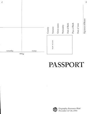
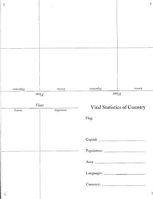


"Passport Assembly:
Photocopy the two 8 1/2 x 11" passport templates at right (above) and distribute one set to each student. Have the students assemble their passports in the following way:

A. Cut the two 8 1/2" x 11" pages apart along the dotted line if they were photocopied together.

B. Place each of the two pages, blank side down, on a flat surface in front of you so that you can read the words "PASSPORT" and "Vital Statistics" correctly.

c. Fold each page in half, across the center, with type facing outward. The words "PASSPORT" and "Vital Statistics" should now read across near the top of each fold.

D. Fold each paper again, like a book, so that the words "PASSPORT" and "Vital Statistics" are on the covers.

E. Insert the section with "Vital Statistics" into the center of the "PASSPORT" section and staple together along the edge of the spine-so that the staple ends are on the back side of the booklet. "

Thursday, January 21, 2010

SkyWatch Friday

To see other interesting sky views:
These photos are not necessarily sky views, but definitely sky-ward looking!
These rock formations are found in Weber Canyon (Wasatch "back" of the Wasatch Front Range Mountains in Utah) and are locally called "The Devil's Slide". I found a great Utah Geological Survey website that describes how this formation came to be as seen today.
http://geology.utah.gov/surveynotes/geosights/devilsslide.htm


Friday, January 15, 2010

SkyWatch Friday

See other interesting sky views:
http://skyley.blogspot.com


A flock/covey of morning doves have taken up residency in
my backyard; mostly harvesting the morsels of food from three
flowering pear and two crabapple trees. This is not exactly a
a sky view, but it has been so smoggy and foggy here lately that
our Utah mountains and skies are hidden...catching a picture or two of the
birdies is just about the only thing not hidden in the fog.

HURRY UP SPRING, PLEASE!!!


Tuesday, January 12, 2010

Desert Ecosystems

Lake Mead National Recreation Area has a guided walking tour showing 5 different examples of desert ecosystems. These are my photos from the tour. This site has a TEACHER section with many resources and geography based lesson plans
http://www.nps.gov/lame/index.htm

DESERT WASH ECOSYSTEM

CREOSOTE BUSH COMMUNITY

DESERT SPRING COMMUNITY

JOSHUA TREECOMMUNITY

CLIFF COMMUNITY

Friday, January 8, 2010

The Known Universe

From American Museum of Natural History...AMAZING

The Known Universe takes viewers from the Himalayas through our atmosphere and the inky black of space to the afterglow of the Big Bang. Every star, planet, and quasar seen in the film is possible because of the world's most complete four-dimensional map of the universe, the Digital Universe Atlas that is maintained and updated by astrophysicists at the American Museum of Natural History. The new film, created by the Museum, is part of an exhibition, Visions of the Cosmos: From the Milky Ocean to an Evolving Universe, at the Rubin Museum of Art in Manhattan through May 2010.

Data: Digital Universe, American Museum of Natural History
http://www.haydenplanetarium.org/univ...


SkyWatch Friday


See other interesting sky views:
http://skyley.blogspot.com/

Two contrasting photos taken during the cold, smog-filled Utah Valley skies typical of inversions this time of the year. The first "darker" image taken as the sun was setting...you can almost see a sundog around the hiding sun. The second photo is of Wasatch Mountains peaking up through the smog...A.M.


Tuesday, January 5, 2010

EarthSky.org Geography podcasts

http://earthsky.org

Listen to FREE, ONLINE ,daily, EarthSky.org podcasts...fascinating science, space and geography subjects! You may download the daily/weekly podcasts or embed their podcasts into a blog, etc.

I used them every morning with my 6th grades classes as a "listening" (comprehension) class starter. The kids listened to the podcast, jotted down a few notes about what they heard and we discussed the topic for a few minutes. The kids turned in their "Earth&Sky" notes every Friday...I was able to give them a comprehension and class participation grade from their work.

(turn off the music gadget in the sidebar if you wish to listen to the podcasts now...)


Sunday, January 3, 2010

Partners Video Magazine

Partners is an award-winning video magazine produced by the Cooperative State Research, Education, and Extension Service (CSREES). It highlights the programs and accomplishments of the partnership between CSREES and the Land Grant University System in the areas of research, education, and extension.

Great Resources for teachers and students. Videos available for FREE download..many subjects. See the following link for more information about the Partners Video Magazine from CSREES:

Partners Video Magazine

Saturday, January 2, 2010

Economic Geography

If you are looking for lesson plans for economic geography subjects, THE best place to head for teacher resources and lesson plans is THE COUNCIL FOR ECONOMIC EDUCATION:
http://www.councilforeconed.org

This website is LOADED will all types of lesson plans and teacher resources on curriculum based, grade-leveled , economic subjects (many geography based!!).

Teacher training, newsletters, reports, publications and lesson plans available at this website.
Virtual Economics has thousands of lesson plans (subscription fee), but EconEdLink &
Civics & Government, & Economics International links have hundreds of FREE lesson plans!!!

Check out their website...too many GREAT resources to list everything here......

The following video was downloadable from the above website:

Footsteps of Alexander the Great: History/Geography

Many years ago, PBS created a fabulous TV series titled: "In the Footsteps of Alexander the Great."

The series was about Michael Wood's multi-year project of retracing on land the travels of Alexander the Great...following ancient writings, modern folk lore and rumors the trip became an award winning documentary.

This series used to be supported on the PBS website with TONS of educational materials, but it is no longer available. Only the series is available in DVD or book..both of these are available from Amazon.com

Social Studies/history teachers that teach about Ancient Greece...This series is an excellent documentary not just for the history component, but for teaching geography as well .

This series is well worth watching &/or adding to your personal teaching materials. I showed many portions of the video and had the students map his journey on their own maps of Asia.

You may be able to check this out at a public library or check your district or school's media center ...maybe available at these places?

The DVD set & paperback book are available from Amazon.com:
http://www.amazon.com/Footsteps-Alexander-Great-Region/dp/B0002CH90K/ref=pd_sim_b_3