NGS Daily jigsaw puzzles

Thursday, August 27, 2009

Where in the world is Mike Perham?

Have your students read about--and map-- the sailing routes taken by Mike Perham, the youngest person to sail around the world without assistance!!
Read about his sailing adventures on his blog: http://www.totallymoney.com/sailmike/
Mike's travels and adventures are recorded on his blog...includes video, voice recordings and maps of his routes....


8/27/09 LONDON (AP) - "A 17-year-old British sailor became the youngest person to sail around the world without assistance on Thursday, completing the solo trip in nine months.Mike Perham. (Barry Batchelor / Associated Press)Mike Perham grabbed the solo record after completing the 28,000-mile trip, crossing the finish line in Cornwall, in southern England. He is now sailing to Portsmouth for a celebration on Saturday"

For more details see the above blog or this news link:
http://msn.foxsports.com/other/story/9992344?GT1=39002

Monday, August 24, 2009

Monster of the Milky Way, Great PBS program!


PBS sends weekly program e-updates about their cool science programs. This week's MONSTER of the MILKY WAY is about the hunt for the supermassive black hole lurking at the center of our galaxy...GREAT CLASSROOM resources for kids and teachers!!! At the above website for this program you may: watch a preview, watch the whole program online, see podcasts, find additional links and books, a teachers' guide and newsletter.

Friday, August 7, 2009

MSN's BING: Geography based

Wow I've been away for awhile, but need to share a cool, albeit indirect geography site!!

MSN Live Search engine--now renamed and redesigned as BING search engine-- has an incredible geography based website!! Each day the BING website background picture changes. The photos are of beatiful locations/cultures/people/cities all over the world. The great thing is that as you scroll over the background picture, little bits of info about the site pop up with additional links that tell about the city, place, culture, etc!!


http://www.bing.com/?scope=web&mkt=en-US&FORM=WLMLQB


This could be used everyday as a geography "class starter" activity to get the kids settled down and focused on your geography subject...You could even use the pop up bit of information as a kind of quiz or subject starter.....ENJOY!!!!!!

Wednesday, June 17, 2009

Importance of being bilingual

I found this commercial a while ago....
learn another language...
learn about another culture...
The importance of being bilingual in our complicated
and interconnected world today.
This is not a current ad...but a great commercial nonetheless.

Thursday, June 4, 2009

SkyWatch Friday


See other beautiful
sky scenes @:
http://skyley.blogspot.com/


I recently visited the WWII Monument in Washington, D.C....
Beautiful, inspiring, HUGE, monument located on the mall
half-way between the Washington and Lincoln Monuments.
This monument is a reverent and respectful place. It
painfully reminds of the past, but looks skyward to a
better future made possible by those who sacrificed
their lives to help end WWII.


Wednesday, June 3, 2009

NGS Education Update: Education Network Newsletter

National Geographic has an online FREE Education Network Newsletter available that is LOADED with lesson plans, program updates, all high quality geography resources!! They frequently send out the newsletters with all types of news and resource updates. The Newsletter is available for free, simply by registering on the site. The current Newsletter can be found at: http://newsletters.nationalgeographic.com/PS!/z4fvgDkqbUFBgIAAAAGCgFICgg0ODc2OTg1MwoKMTYxMDgxMTQxNQkAJdhZCgkzOTA4NjY4ODYF
The newsletter is extremely teacher & kid friendly providing useful resources, quizzes, explorations, Geographic Bee info, videos, and links to other geography related programs and materials. Sign up to day...this is an essential website to put in your teachers "geography resource toolkit" !!!

Wednesday, May 27, 2009

EARTH 2 U / GEOGRAPHY: CULTURAL COLLAGE


EARTH 2U: EXPLORING GEOGRAPHY
WHAT A FUN AND INTERACTIVE WAY TO INVOLVE STUDENTS IN GEOGRAPHY!!
EARTH 2U Project Details:
"The Smithsonian Institution and the National Geographic Society contacted ETG to help them create the "Earth 2U: Exploring Geography" CD-ROM. Olympic gold medalist Dan Jansen and a comic cartoon character named Seymour D. Earth are the hosts of this digital, interactive translation of the widely acclaimed "Earth 2U" national touring exhibition.
Packed with interactivity, things to explore and games to play, "Earth 2U: Exploring Geography" teaches kids fun facts, history and stories about the world. Kids make connections between people, places and the environment and see why these links are so important in our global society. Hands-on fun includes movies, maps and interactive games, even 3D aerial views of different landscapes. "
http://stg.missouri.edu/Interactives/earth2ut/
http://stg.missouri.edu/Web/earth2u/
Smithsonian archived site for Earth 2U: Exploring Geography materials:
http://www.sites.si.edu/exhibitions/exhibits/archived_exhibitions/earth2u.htm

The following pages were teacher/student materials from a poster produced for
Earth 2U: Exploring Geography. Copy and make overhead transparencies of each page...place each transparency on top of the other...to create the "layers" of geography involved with when studying a world culture --the land,the people, language, technology, institutions and beliefs.
(double click on each page to enlarge... print using landscape mode)
("copyright: 1995 Smithsonian Institution. Photocopying for Educational purposes encouraged.")


Friday, May 22, 2009

SkyWatch Friday

I just got back from Washington, DC. after seeing the National Geographic Bee Finals May 18-21. While in D.C., I was able to take in a few of the sites, including visiting our Nation's Cathedral...Beautiful and humbling architecture..inside and out!!!! I could help but look skyward in the amazing place!!!


See other beautiful sky views @


Friday, May 15, 2009

SkyWatch Friday


Look Up! See other beautiful sky views@
BIRD'S EYE VIEW--
ROBIN UPDATE:
Mrs. Robin nesting upon my rain gutter is seriously settled into the business of hatching her eggs!Baby Robins soon!!! She is keeping a watchful eye on me and anyone who
passes her nest!!


And now a bigger sky picture:
Looking West across the Salt Lake Valley (Utah) to the Oqirrh Mountain range & "Kennecott" (Rio Tinto) open-pit Copper Mines....example of human/environmental interactions!

Wednesday, May 13, 2009

Desk-Top Country Geography Project


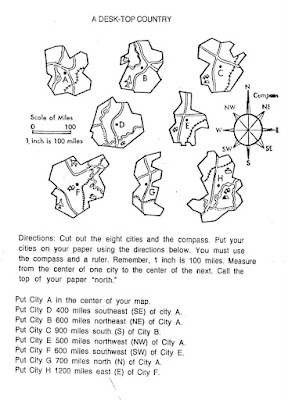
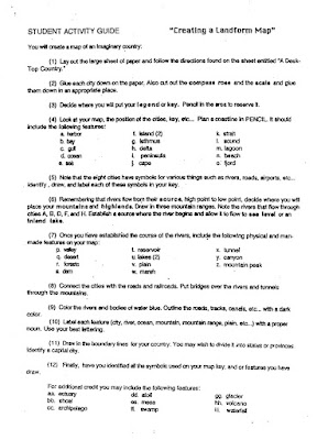
DESK-TOP COUNTRY

This is a great end-of-school-year geography/art project! I've used this project for many years and with different ages of students., and it has ALWAYS been a fun, creative, insightful, exciting, culminating (great assessment), and successful geography project. This project can be given as an assignment to individual students or to groups of students. It takes several days to complete...especially when working in groups. The assignment involves locating (according to directions) the map pieces (provided) on a blank sheet of paper and then creating a town/city/state/country "around" the map pieces incorporating physical, man-made, and political features on their "country map".

Each student (or group) needs a large sheet of butcher/roll paper or poster board and copies of the two instruction sheets provided on this blog. (To make copies of the instruction worksheets..right-click on each document and select "print target"). Following directions on "Desk-Top Country" cut out the map pieces on the worksheet and place them on their large sheet of paper according to the directions on the worksheet. As students arrange the map pieces on their papers, check to see that the arrangements are correct..this will save many problems later on in the project.) Once all of the pieces are correctly placed on their papers...as instructed on the second sheet...ultimately creating their own town, city, state or country! This is a amazing project, map keys/symbols, landforms, water flow direction, transportation routes, climates, community needs, agriculture..etc., etc.,)

Honestly, I don't know where (or from whom) I originally acquired this project, but I have used it
very successfully for years. It is NOT MY CREATION! So, I humbly and greatfully
give credit to the original author (unknown) of this fabulous project!!!


Friday, May 8, 2009

SkyWatch Friday...pink blooms

See other amazing sky views @
This is an interesting photo. I have a little league baseball field located to the west of my house...and bright light from the night time games shines over the top of my house
into my backyard. The light illuminating these pink blooming crabapple trees was a very eerie scene.

This "sky view" is overlooking the many beautiful blooming peach orchards of Perry, Utah and westward to the
Great Salt Lake., Utah, USA.


Monday, May 4, 2009

GeoSpatial Revolution

A friend shared information about an huge geospatial geography project at Penn State University:
Geospatial Revolution Project ..The location of anything is becoming everything! http://geospatialrevolution.psu.edu/index.html

The project is under developement..sign up for updates!!

Info about the project from thehttp://geospatialrevolution.psu.edu/index.html website:
"We live in the Global Location Age. “Where am I?” is being replaced by, “Where am I in relation to everything else?”Penn State Public Broadcasting is developing the Geospatial Revolution Project, an integrated public media and outreach initiative about the world of digital mapping and how it is changing the way we think, behave, and interact.The project will feature a web-based serial release of eight video episodes—each telling an intriguing geospatial story. Overarching themes woven throughout the episodes will tie them together, and the episodes will culminate in a 60-minute documentary. The project also will include an outreach initiative in collaboration with our educational partners, a chaptered program DVD, and downloadable outreach materials."

WE SHALL REMAIN

PBS Television has produced an incredible new series and resource for social studies teachers: WE SHALL REMAIN
From the PBS site: http://www.pbs.org/wgbh/amex/weshallremain/the_films/about

"At the heart of the project is a five-part television series that shows how Native peoples valiantly resisted expulsion from their lands and fought the extinction of their culture -- from the Wampanoags of New England in the 1600s who used their alliance with the English to weaken rival tribes, to the bold new leaders of the 1970s who harnessed the momentum of the civil rights movement to forge a pan-Indian identity. We Shall Remain represents an unprecedented collaboration between Native and non-Native filmmakers and involves Native advisors and scholars at all levels of the project."

The 5 episodes can be viewed online, and extensive teacher materials are available for each episode:
http://www.pbs.org/wgbh/amex/weshallremain/beyond_broadcast/teach_and_learn

Ge...MOOOO...graphy cartoon

Sharing another GE-MOOOO-GRAPHY cartoon!


Geography comic strip

sharing Another great geographic cartoon/comic strip...especially funny to those of us that live in and around BIG Mountains...hahhhahhha


Geography video: Playing for Change

WOW what a powerful music project! I heard about this on NPR Morning Edition today...had to share!!!

http://playingforchange.com - From the award-winning documentary, "Playing For Change: Peace Through Music", comes the first of many "songs around the world" being released independently. Featured...
http://www.youtube.com/watch?v=Us-TVg40ExM