NGS Daily jigsaw puzzles

Thursday, February 26, 2009

SkyWatch Friday

See other SkyWatch Friday views:
http://skyley.blogspot.com/

It was a dark and gloomy winter morning.....
I took this photo last week, the dark snow/rain clouds were rather foreboding..

Feb/09 Wasatch Mountain Range, near Mt. Timpanogos, northeastern Utah Valley, Utah, USA

"How the World was Made", new series

The HISTORY CHANNEL has an amazing new series HOW THE EARTH WAS MADE. Geography, Geology, oceanography, hydrology + many other topics are covered in this series.http://www.history.com/video.do?name=How_the_Earth_Was_Made&bcpid=9786056001&bclid=13744421001&bctid=13764655001


The above clip was downloaded via MSN.com today from the "How the Earth was Made" series:
From the HISTORY CHANNEL website: "The new series HOW THE EARTH WAS MADE travels the globe to reveal the geological processes that have shaped our planet. Each episode will look at a single location and examine how the features that we see today have formed over millions of years—whether by colliding continents, volcanic eruption or the abrasive power of vast ice sheets. These processes, which intimately affect the way we live today, have been lost in the mists of time. Using the clues that were left behind, combined with expert evidence from geologists in the field, this series rolls back the millennia to see how the slow but immensely powerful forces of geology have shaped our world."

You can show these videos to your students from the website, purchase the series on DVD. The videos will not download from the History Channel website, but you may video tape the series for free useage in the classroom for one year. See the "classroom" link on the main website for recording rights. The videos do have adertisements. From >History Channel Home Page> Classroom > at this link you may also sign up for a HISTORY CHANNEL newsletter that will send you email updates about the latest series showing etc.

Wednesday, February 25, 2009

Geography of "Rock 'n Roll"?


I found an odd, but interesting site linking geography to music...
http://www.jananddean-janberry.com/maps/maps.html
This website has a map of Southern California indicating locations of
all the places mentioned in songs by the singing duo
Jan & Dean as well as The Beach Boys...also places where the groups lived, worked, recorded songs..all California locales.
Interesting twist to teaching Southern California geography????

Tuesday, February 24, 2009

World Festivals

Pre-Lent holidays celebrated differently around the world: Mardi Gras, Fat Tuesday, Carnival....

This video was available for download today 2/24/09 on MSN.com...great segment from the History Channel about the geography & history of pre-Lent world celebrations.

Saturday, February 21, 2009

How to dig a hole to the center of the earth

http://browseinside.harpercollins.com/index.aspx?isbn13=9780064432184

Speaking of clay...I've had students build a cross-section model of the earth's inner layers in conjuction with the story: How To Dig A Hole To The Other Side Of The World, by Faith McNulty.
As you read this story to your students (assign students into teams of two) each team will model the different layers of the earth using clay as described in the story: core (small marble- sized ball) in a red clay, inner/outer mantle (surround the core with a different-colored layer of clay about 2" or more thick), and the crust (thin layer of blue-colored clay about 1/4" thick covering all of the mantle layer). When the story/models are completed, students (with a piece of string or a plastic knife) then cut the earth model in half. Each person then gets a "hemisphere" ....and students make little labels for each of the earth's layers (attach label to a toothpick or straight pin) and insert into the clay to identify the earth's inner layers. Great 3-dimensional geography/art projects for displays and take home.


I found a few more lesson plans (with lots of extensions) that relate to teaching about the inner layers of the earth. These lessons also use: "How To Dig a Hole to the Other Side of the World."

http://www.usmint.gov/kids/teachers/lessonPlans/50sq/2005/0406-3.rtf
http://www.thesolutionsite.com/lesson/1206/watsonelB1.html

http://www.nku.edu/~enved/services.htm

Realistically, we could not dig to the other side of the earth....but if we could? The following fun websites below will show you where you would exit (antipode locations) ...if you could dig to the other side of the world!!!!!
http://www.freemaptools.com/tunnel-to-other-side-of-the-earth.htmhttp://www.antipodemap.com/

Friday, February 20, 2009

SkyWatch Friday

See what others are
seeing when looking skyward
at: http://skyley.blogspot.com/
Earlier this week, in the morning before work, I saw this almost fully round "sun dog" !! The day was clear and sunny but there was a hazy foggy area as I neared my work. The result was a fully round
sun dog (rainbow) from the sun peering through the haze.
This photo shows the sun dog, but the actual sun dog was
more colorful. I took this photo right outside the front door
of my work location, but feel lucky to have captured this much of the
sun dog. What a site!!! (The diagonal line in the photo is
an overhead electric line to the bldg.)


Thursday, February 19, 2009

Wednesday, February 18, 2009

Global "play-dough"

Students of all ages enjoy using clay for art projects, but try using it for geography projects as well! Using clay is a great way for students to learn vocabulary/tearms of physical geography features. For this project, send the following clay recipe home with students a couple of weeks prior to the activity date...ask them to make three batches of clay if possible in different colors: blue, green, & white (plain/no color). This recipe is one of the best that I have used for clay projects, because it's 1)fairly easy to make, 2) can be repeatedly re-used for different projects (if stored in plastic zip-bags or containers), and 3)projects made from this clay dry slowly, hold together for quite a while (and do not crack/fall apart).


GLOBAL "PLAY-DOUGH" recipe:
MIX:
1 cup flour
1 cup water (food coloring can be added here)
1/2 cup salt
1 tablespoon vegetable oil
1 teaspoon cream of tarter
COOK:
Cook the above ingredients in a cooking pot over low heat...stirring constantly...until thick and lumpy. ( the dough will stir into a ball)
KNEAD:
When the dough has cooled, knead the dough for several minutes. (If the dough is too wet or sticky...it's not "cooked" enough...reheat in pan).
Let kneaded dough cool completely...store in plastic zip bags or plastic containers. The dough can also be refridgerated.

Global "play-dough" physical features ideas:
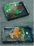
1) cut 6 in x 6 in squares of poster board or cardboard. Write three similar physical features vocabulary words on each board. Give each student (or pairs of students) a vocabulary board & clay...they must look up the definition of the words...& write them on the back of the card. Then the students use small amounts of clay to "model the physical feature".

Examples of geography physical features words for the cards:
key, island, boundary
source,lake, upstream
tributary, plateau, mesa
mt. pass, butte, canyon
island, bay, shore
point, reef, ocean
reef, compass rose, harbor
delta, harbor, bay
mesa, butte, plain
plain, peninsula, cape
cape, point, gulf
gulf ,bay, strait
boundary upstream island
mt, lake, forest
mouth(river), source, river
hill, plain, downstream


Students can make little labels to identify each physical feature...attach the labels to straight pins or toothpicks and insert into the clay. Students show the class their finished physical features definitions and "models"...As the students are explaining their models, the rest of the class writes the definition and sketches a pictures of the model as well. The students notes/sketches could be taken on a worksheet, journal, or 11x17 art paper folded into 16 squares.

Thursday, February 12, 2009

SkyWatch Friday

See what others are seeing when
looking skyward:
http://skyley.blogspot.com/

Birds of a feather,
flock together.....

(in this case, to keep WARM!!)

Wednesday, February 11, 2009

CIA WORLD FACTBOOK


https://www.cia.gov/library/publications/the-world-factbook/index.html
Another marvelous and FREE geography resource for teachers and students is (CIA's) The World Factbook. These materials (used to be available in print), can be downloaded at the above website.

From their website:"The World Factbook is no longer available in a print edition. The CIA has made a decision to focus Factbook resources exclusively on the World Wide Web online edition, which is updated with new material every two weeks. Please look for the newly redesigned Factbook website coming in spring 2009. "

https://www.cia.gov/kids-page/index.html The Kids' Page has an online library of the World Factbook, Parent/teacher resources, games, even CIA career information, maps, current world leaders, etc. Lots of FREE student resources available for reports and research.!!!

CountryReports.org

http://www.countryreports.org/
Do you need a single-stop website for students to find information about countries for reports?
CountryReports.org is a wonderful site filled with all types of information: country geography/maps, country histories, cultural information, ethinic recipes, photo gallery, current events etc needed for student country report research. There are plenty of teacher resources as well!!!
This is as pay for use site, but the prices are very reasonable. Licenses are available for a single computers, your school computer labs, your school library, or entire school use.

Thursday, February 5, 2009

geoGreetings


http://www.geogreeting.com/
What a fabulous and fun way to experience geography!!!
GeoGreeting from Google Earth lets you type a message or geoGreeting email....but the letters are spelled out in the shapes of buildings from around the world!
Using this website would be a great geography activity to use during your computer lab time, or use on a SmartBoard, on a single classroom computer or as homework. (Have your student's send a geoGreeting to your school email!)
And.... what a fun way to get the little kidlets to practice their alphabet!!!!

Monday, February 2, 2009

World Hazards & Earthquakes

For latest reports of geologic hazards & earthquakes in the U.S./World see United States Geological Society http://earthquake.usgs.gov/. Free teacher information available: podcasts, newsletters, online lectures, GIS/GPS information, maps, videos, publications, career information,

On the same website, interactive information about earthquakes for kids:
http://earthquake.usgs.gov/learning/kids/

Geography Simulations


Are you looking for fun, interactive class simulations to teach your students geography? Check out INTERACT simulations

This company produces fun, challenging, hands-on, interactive group/class simulations for students concerning many subjects including geography &/0r social studies. The simulations include the the activities (w/ teacher lesson plans), scheduling details, student worksheets and background information. I have used several of these simulations over the years, and the students always loved the fun, crazy learning activities provided in the simulations.
My Favorites: Caravans (world geography), Athenian Secret (Ancient Greece+geometry), King Lexicon (Middle ages+dictionary work), Pioneers (stuggles of American pioneers), Greeks (ancient greece history), Dig (archaeology), Fitness (circulatory system and fitness activities), and many others. Some of these simulations require more class time than others, but can be adjusted for shorter time periods. Everytime I used these simulations with my classes, the kids loved the activities and hated to see the simulation end!!!!
(Prices vary, but overall I've found them very resonable for all the materials you get with the teacher/student materials. The materials are reusable, so you may be able to use textbook funds?)
Many of my most wonderful memories from teaching had to do with crazy moments from these INTERACT Simulations!!!